 |
| Lawn Hill Gorge at Boodjamulla National Park |
Aug 24-28
Viajamos aproximadamente 1300 Km de nuevo al norte para visitar Boodjamulla National Park. La primera parte del camino supuso el cruce de la Diamantina, una zona desértica que empieza tener influencias de las tierras del canal. Cerca a Bedourie, los Lagos y los pequeños Ríos asociados con el canal, incluyendo el río Diamantina, proporcionar la hidratación suficiente para que la vegetación alrededor de la carretera y de los cuerpos de agua sea de un verde reluciente, con ella los pájaros principalmente aquellos acuáticos hace su aparición, pelícanos, terns, zebra finches, grebes, ducks and martins llenan el paisaje de sonidos, vuelos y colores.
 |
| Flock of Bronzewing with wild flowers on our way to Bedourie |
We travelled approximately 1300 Km north again to visit Boodjamulla National Park. The first part of the road involved the crossing of the Diamantina, a desert area which begins to be influenced by the channel lands. Close to Bedourie, the lakes and the small rivers associated with the channels, including the Diamantina River, provide sufficient water that the vegetation on either side of the road and the bodies of water are a gleaming green, and with this the birds, mainly aquatic, make their appearance: pelicans, terns, zebra finches, grebes, ducks, and martins fill the landscape with sounds, flight, and colours.
 |
| Pink-eared Duck at Diamantina Channel |
Después de una tarde de apreciación lenta, llegamos a Bedourie un pequeño poblado de 105 habitantes con un hotel, un centro acuático, dos campamentos y un Casa de ruta, caminamos el pueblo para explorar su ambiente y como ha sido común en Australia, todo estaba cerrado, todo estaba tranquilo, todo estaba apagado, era sábado, así que nuestra única opción era la casa de ruta, allí el restaurante estaba ocupado por algunos visitante, el bar tenía otros tantos y dos pantallas gigantes transmitían los juegos de Rugby League: ese fue el plan, rugby y cena, bueno eso es mucho decir, comida de bar.
 |
| Diamantina River |
After an afternoon of slow appreciation, we arrived at Bedourie, a small town of 105 inhabitants with a hotel, an aquatic center, two campsites, and a roadhouse; we walked the village to explore its environment and as has been common in Australia, everything was closed, everything was quiet, everything was off, it was Saturday, so our only option was the roadhouse, there the restaurant was occupied by a few visitors, the bar had many others and two giant screens transmitted the Rugby League games: that was the plan, rugby and dinner, well that's saying a lot, and bar food.
 |
| Going north to Boulia |
 |
| Brown falcon on Vaughan Johnson Lookout |
El siguiente día viajamos hacia Boulia, el paisaje se hizo progresivamente más verde, Boulia es la transición entre el desierto y las tierras del canal, así lo árido sirve de telón de fondo para los pastos, la vegetación y las flores silvestres. El siguiente pueblo fue Boulia, un poblado no más grande que el anterior, más amigable y con carácter. Continuamos al norte en dirección a Mount Isa, la monotonía de los pastizales se quiebra con la presencia de Argyle Range, montañas que cruzamos varias veces siguiendo la ruta. Mt. Isa es una ciudad pequeña que creció gracias a la minas de iron, plomo y otros minerales al inicio del siglo XX. Ahora con una industria minera claramente establecida, es el lugar perfecto para atender los asuntos de la vida cotidiana en remoto outback de Queensland.
 |
| Landscape near Mt Isa. |
 |
| Spotted Bowerbird and its bower at Mt Isa. |
The next day we traveled to Boulia, the landscape became progressively greener; Boulia is the transition between the desert and the channel lands, thus the arid landscape serves as a backdrop for pastures, vegetation, and wild flowers. Boulia is a town no bigger than the previous one, however more friendly and with character. We continued north in the direction of Mount Isa, the monotony of the grasslands was broken with the presence of the Argyle Range, which we crossed several times following the road. Mt. Isa is a small city which grew thanks to the mining of iron, lead, and other minerals at the beginning of the 20th century. Now with a clearly established mining industry, it is the perfect place to address the issues of everyday life in the remote Queensland outback.
 |
| Leaving Mt Isa. |
The first part of the road out of Mt. Isa to Cloncurry undulates through rocky outcrops , an attractive start to the day’s journey. Turning north the road became less interesting - flat grassy lands. At Burke and Wills Roadhouse we turned west towards Gregory, after which the tarred road gave way to a mixture of tar, good gravel, disappearing bitumen, and devilish corrugated gravel; overall it was a dry dusty and largely monotonous day, although we were pleased to see a group of Brolga at the side of the road.
 |
| Road from Gregory Downs to Boodjamulla N.P. |
La primera parte del camino saliendo de Mt. Isa hacia Cloncurry, es una ruta ondulada a través de afloramientos rocosos, un comienzo atractivo para el viaje del día. Girando hacia el norte, el camino se convirtió en pastizales planos y menos interesantes. En Burke and Will Roadhouse, giramos hacia el oeste en dirección a Gregory, después de lo cual un camino asfaltado dio paso a una mezcla de grava alquitranada, buen pavimento, asfalto desapareciendo y endemoniadas corrugaciones, sobre todo fue un día seco y polvoriento y en gran parte monótono, aunque nos agradó ver a un grupo de Brolga al costado del camino.
  |
| Views of the river and the sky at our campsite |
Our campsite at Adels Grove was a surprise. Tall trees, on the bank of a tranquil river with lilies and transparent waters. It was remarkable to encounter this green and pleasant oasis. With first light the songs of the birds woke us slowly and the fresh breeze was a caress.
Nuestro campamento en Adels Grove fue una sorpresa. Árboles altos a la orilla de un río tranquilo con las aguas transparentes y llenas de flores de agua. Fue notable encontrarse con este oasis verde y agradable. Con la primera luz el canto de los pájaros nos despertaron lentamente y la brisa fresca fue una caricia.
 |
| The gorge |
We drove a short distance to reach Boodjamulla National Park, the waters which flow past our campsite flow down from this park, where they descend from springs then form wide pools with waterfalls at several points, creating the Lawn Hill Creek. The creek is confined by the steep cliffs of the gorge, which has cut through the red Constance sandstone. We explored the gorge on the water, preferring this to walking trails on the gorge’s rim, the sensation of the wall
is magnificent.
 |
| Transparent waters at Lawn Hill Creek |
Condujimos una corta distancia hasta el Parque Nacional Boodjamulla, las aguas que fluyen más allá de nuestro campamento fluyen aguas abajo desde este parque, donde descienden de manantiales y luego forman amplias piscinas con cascadas en varios puntos, creando el arroyo Lawn Hill Creek. El arroyo está confinado por los empinados acantilados del cañon que ha atravesado la arenisca roja de Constanza. Exploramos el cañon a través del agua, prefiriendo esto a caminar por el borde del cañon, la sensación de las paredes
es magnífica.
 |
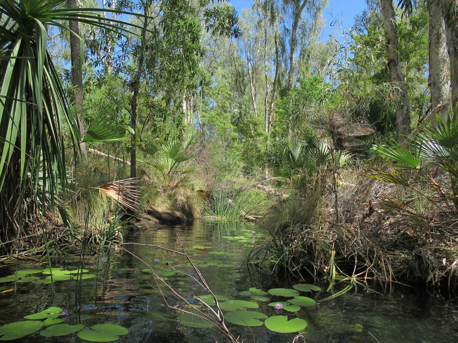
| Channels at the upper section |
The park offers two options on the water: the solar powered boat cruise and human powered canoes - we used the second. Close to the slip, the water is full of lilies, it’s so clear that is easy to see the the roots of the plants and the fish weaving between them, different trees and palm accompanies the watercourse and many small birds fly around. At the end of the middle section
we arrived at Indarri Falls, where a dock is available to tie up the canoe so that one may swim below the falls. One can also portage the canoe to the upper section of the creek and continue as far as the small channels where water flows into the upper part of the gorge; we chose to do this, to explore the upper part, returning for a swim at the falls on the way back. In this section, the landscape continued astonishing and the water of the pool at the base of the falls highly refreshing.

El parque ofrece dos opciones en el agua, un crucero en un barco propulsado por energía solar y canoas que usan energía humana, utilizamos la segunda. Cerca de la entrada al agua, el arroyo está lleno de flores de agua, la cual es tan clara que es fácil ver las raíces de las plantas y los peces que tejen entre ellas, diferentes árboles y palmeras acompañan el curso de agua y varias aves pequeñas vuelan alrededor. Al final de la parte central, llegamos a las cataratas Indarri, hay un muelle disponible para amarrar la canoa y nadar debajo de las cataratas. También, se puede transportar la canoa a la sección superior del arroyo y continuar hasta alcanzar los pequeños canales donde el agua fluye hacia la parte superior del cañon, elegimos hacer esto, explorar la parte superior y nadar en las cataratas en el camino de regreso. En la sección superior el paisaje continua impresionante y las aguas en la piscina a la base de la catarata altamente refrescantes.
 |
| Fish at the upper section |
After a short rest we took a walking trail to explore the lower part of the creek; on the way large trees which had evidence of previous flooding stand on grey sandy land, then we walked around the base of the the island stack, whose walls have evidence of aboriginal art; finally, at the lookout onto the lower section of the gorge, we rested while we enjoyed the silence and tranquillity of the place, with bowerbirds courting, sulphur-crested cockatoos flying back and forth, and a wallaby grazing at the water’s edge.
 |
| Wallaby at lower section of Lawn Hill Creek |
Después de un pequeño descanso, tomamos un sendero para explorar la parte inferior del arroyo, en el camino se erigieron grandes árboles que tenían evidencia de inundaciones preciosas en una tierra de arena gris, luego caminamos alrededor de la base de la pila de la isla, cuyas paredes tiene evidencia de arte aborigen, finalmente, en el puesto de observación de la sección inferior, descansamos mientras disfrutamos del silencio y la tranquilidad del lugar, con great bowerbird cortejandose, cacatúas de cresta azufre volando de un lugar para otro, mientras un wallaby se asoma tranquilo al borde del aguas.
Abrazos, Hugs
Alan y Marce
Photos may be used for non-commercial purposes with credit to alanymarce@gmail.com


No comments:
Post a Comment